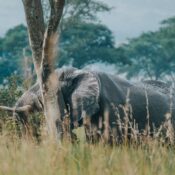

Virunga-hiking
The name “ Mufumbiro Mountains ” simply means “ Mountains that Cook ” which, in relation to the volcanic tendencies of these ranges, makes quite the befitting name for these Mountains. But no matter how many pictures you see or information you read, this journey is worth taking and seeing through your own eyes! The Mufumbira ranges of Uganda will totally blow your mind with such beautiful scenery and a lot more that you will just have to come experience for yourself!
The Mufumbira Ranges ( Virunga Mountains ) Of Uganda Consist Of Three Mountains That Include
- Mount Sabinyo
Sabinyo is an extinct volcano west of Lake Bunyonyi, Uganda’s deepest lake and north east of Lake Kivu. It is probably the most interesting among the three because it gives its visitors an opportunity of being in three countries i.e. Uganda, Rwanda and Democratic Republic of Congo at the same time without needing visa. Sabinyo is a local term that means, “old man’s teeth” and it was named so due to the way its peak is shaped with years of erosion. Sabinyo stands at an elevation of 3645 m above sea level and a hike to the top takes between 7-8hours.

sabinyo
- Mount Gahinga
Conveniently located inside Mgahinga Gorilla National Park, Gahinga lies at an altitude of 3,447 m above sea level with a swampy caldera at its peak approximately 180 m wide. This range lies right in the middle of Muhavura and Sabinyo and is smaller than the two. A hike up can take approximately 6 hours. One can combine the activity of Gorilla tracking and Golden monkey trekking with a hike to the top of Gahinga. The name Gahinga means pile of stones which is quite evident with many volcanic rocks that lie at the foothills of the mountain and in people’s gardens, giving full proof of the volcanic activity that happened thousands of years ago.
- Mount Muhabura
Muhabura is an extinct volcano with the highest peak among these three standing at an altitude of 4,127m above sea level. The hike to the top of Muhabura takes about 8 hours depending on the fitness of an individual and it gives you an awesome view of, Volcanoes, Lake George and Lake Edward of Queen Elizabeth National Park, Rwenzori Mountains as well as Bwindi impenetrable.
for more information visit